The last weekend of January will be quiet and beautiful with plenty of sunshine — nearly perfect weather. And although the weekend will be uneventful, an active weather pattern begins as early as Monday morning for San Antonio and South Central Texas.
Here’s what you need to know:
SUNDAY
Sunday will start off in the 30s, and be a bit warmer in the afternoon, with a high near 70°
MONDAY
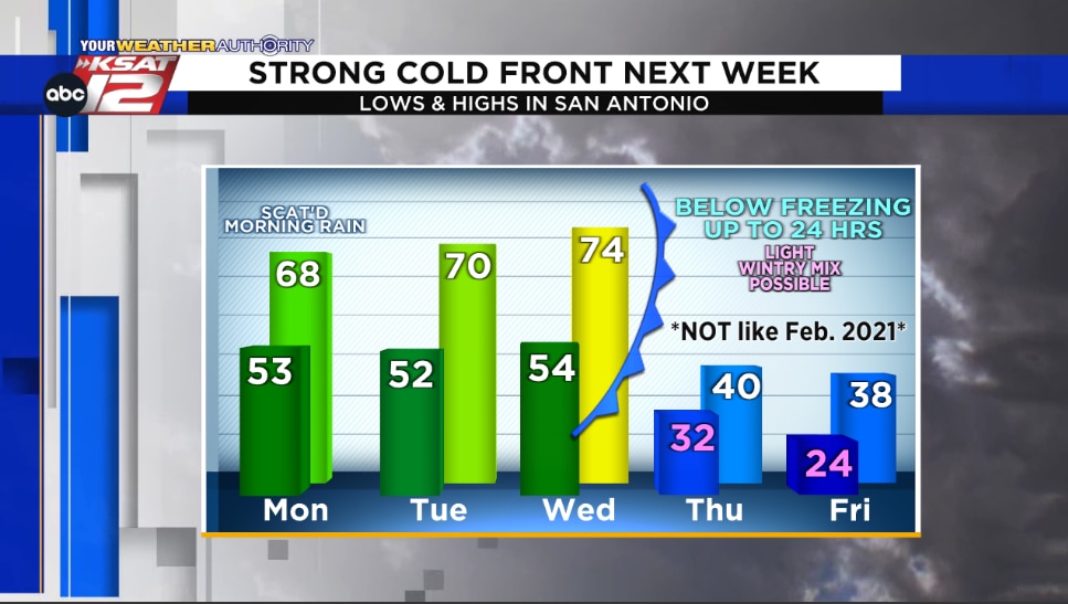
Scattered showers are likely early Monday, mainly east of 281While there may be a few rumbles of thunder, NO severe weather is anticipatedMost rain will clear out of San Antonio by lunch
TUESDAY & WEDNESDAY
Pleasant with highs in the 70s
WEDNESDAY NIGHT & THURSDAY MORNING
A strong cold front will arrive Wednesday nightTemperatures will fall from the 70s Wednesday afternoon into the 20s and 30s Thursday morningWind chills will be in the teens
THURSDAY & FRIDAY
While there could be a light wintry mix of sleet and freezing rain Thursday morning, this will NOT be as extreme as last year’s winter storm — so no need to panic-buy at H-E-B 😊There is the potential to be below freezing for up to 24 hours Thursday through Friday
STAY IN-THE-KNOW
This forecast will evolve slightly in the coming days. You can keep up with your local weather forecast by downloading the KSAT Weather Authority App for Apple or Android. 📱 Be sure to allow notifications for updates, including livestreams from KSAT meteorologists.
If you end up wanting to share weather pictures with the weather team, you can submit photos and videos here, and your submission may get featured on KSAT.com or on air.